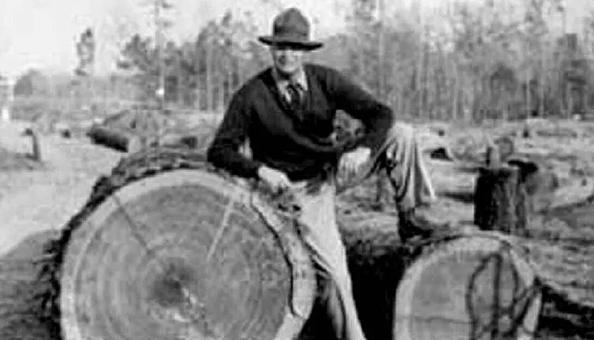
Cypress logs cut from the Santee swamp await transport to sawmills. (Photo from Poe Collection, Clemson University)
Editor’s Note: At the request of his readers and in memory of Warner M. Montgomery, Ph. D, we will continue to publish his Adventure Travel stories for the time being.
The Santee-Cooper Project was a mixed blessing for Pineville, Pinopolis, Eutawville, and other historic plantation sites along the Santee and Cooper Rivers. It brought electricity, flood control, malaria eradication, economic development, and recreation opportunities, but it flooded homes, farms, cemeteries, and churches that had existed since before the American Revolution. And, moreover, it scattered many of South Carolina’s oldest families to the winds.
In 1938, The Santee Cooper Power and Navigation Project began purchasing and clearing over 177,000 acres of land in Berkeley, Calhoun, Clarendon, Orangeburg, and Sumter counties. A survey for the U.S. Department of the Interior by Thomas T. Waterman revealed the following plantations and churches were in the path of the new lakes: Northhampton (1715), Hanover (1716), Belvidere (1786), Eutaw (1808), Pond Bluff (Francis Marion’s home, 1820), The Rocks (1805), The Rocks Church of the Epiphany (1804), Loch Dhu (1816), Springfield (1818), Ophir (1810), Somerset (1827), Mexico (?), Big Camp (?), Mount Hope (?), Bluefield (?), Sussex (?), Cherry Grove (c.1840), Webdo (?), Gravel Hill (?), Johnsrun (c.1793), Richmond (1769), Bunker Hill (1800), Indianfield (1816), Wampee (1824), Whitehall (1824), Cedar Spring (1804), Pooshee (1804), Woodlawn (1810), and Black Oak Church (c.1804).
More than 7,000 graves were scheduled to be covered by the lakes. The S.C. legislature passed an act in 1934 that set regulations for removal of cemeteries and reinterring of bodies. About 6,000 graves were moved by relatives and relocated above the high water. Those not removed were covered by the flood waters. Most of these cemeteries were in Lake Moultrie and were affiliated with black churches. Included were Big Home, Code, Colcolough,
Cuddo, Frierson No. 96, Frierson No. 97, Goshen 11 Plantation, Lawson Nelson, Old Jeruselum, Owens No. 1, Owens No. 2, Sab, Santee AME Church, Society Hill, Taw Caw, Tom Boger, and Wyboo.
Forty-two miles of dams and dikes were constructed, including a 26-mile, 78-foot earthen dike and a 3,400-foot dam at Pinopolis with 62 gates. All total, it cost $42.2 million in federal funds.
This largest land-clearing project in U.S. history hired 12,500 workers from the relief rolls throughout the state. The federal government set up 25 WPA camps to house 6,000 workers—white and “colored” workers in separate camps. Over 200 million board feet of timber were harvested during the clearing of the 225-square mile reservoir.
The dam at Pinopolis included a hydro-electric station and the highest single-lift lock in the world, 75 feet.
An eight-mile-long earthen dam, the longest in the world at the time, stopped the flow of the Santee River. Its mile-long spillway with 62 gates controlled the floods that had always ravaged the Santee floodplain.
The upper lake, Marion, and the lower lake, Moultrie, were connected by a six-and-a-half mile diversion canal. Lake Marion flooded 110,600 acres, Lake Moultrie 60,400 acres. For the second time in history, Columbia and Charleston were connected by water. This time there was no benefit to Pineville. This time the homeland of some of South Carolina’s oldest families disappeared under the waters of Santee-Cooper.
Loading Comments